

Silver Lake is a beautiful alpine lake nestled high up American Fork Canyon with rugged White Baldy as an impressive backdrop. This hike provides impressive vistas and good opportunities to see wildlife along the trail.
Silver Lake
Distance – 4.5 miles roundtrip
Approximate hiking time – 2.5 to 4.5 hours
Elevation at Trailhead – 7535 feet
Elevation at Silver Lake – 8985 feet
Total Elevation gain – 1450 feet
Difficulty – Easy
Trail – dirt, rock
Amount of water recommended – 2 to 3 liters
Bathrooms – Restrooms at the trailhead
Season to hike – April to November
Permits – $6 for 3-day pass or $12 for a 7-day pass purchased at Fee Station in American Fork Canyon
Pets: Permitted. Must be on a leash.
How to get there:
If coming from Salt Lake City take Interstate 15 south and take Exit 284 Highland/Alpine. Turn left (East) onto UT-92 (also known as Timpanogos Highway) Head east on UT-92 for 12.5 miles. (Along the way you’ll pass through a fee station where it is $6 for a 3-day pass.) Continue past the fee station for about 4.7 miles and then take a left (north) onto UT-144. Head up UT-144 for 2.5 miles. After passing Tibble Fork Reservoir on your right, you’ll take a sharp curve to the left on the paved road (now FR 010) up toward Granite Flat Campground. At 0.7 miles from the sharp curve, turn right onto FR 008/Silver Lake Rd. This road is a dirt road and is narrow in some parts. Some people consider this road to be passable for passenger cars. That does not mean it is a good idea. The road can be rough and, unless you drive under 5 mph, you could damage the undercarriage of your passenger car. After a rain it is not recommended as it could be rutted and slick. Follow this road for 3.0 miles, passing Silver Lake Flat Reservoir and arriving at the Silver Lake Trailhead.
If coming from Provo or farther south, take Interstate 15 north to Ext 275 (Pleasant Grove Blvd.) Turn right (east) on to Pleasant Grove Blvd and turn left (north) at the very first stoplight, only 0.3 of a mile after exiting the freeway. This road is 2000 W/N County Blvd. Continue on this road for 5.5 miles. (The name of this road will change several times along the way. Just stay on it until you reach UT-92/11000 North. Turn right (east) onto UT-92/11000 North and follow it for 6.2 miles up the canyon. (Along the way, you’ll pass through a fee station where it is $6 for a 3-day pass.) Continue past the fee station for about 4.7 miles and then take a left (north) onto UT-144. Head up UT-144 for 2.5 miles. After passing Tibble Fork Reservoir on your right, you’ll take a sharp curve to the left on the paved road (now FR 010) up toward Granite Flat Campground. At 0.7 miles from the sharp curve, turn right onto FR 008/Silver Lake Rd. This road is a dirt road and is narrow in some parts. Some people consider this road to be passable for passenger cars. That does not mean it is a good idea. The road can be rough and, unless you drive under 5 mph, you could damage the undercarriage of your passenger car. After a rain it is not recommended as it could be rutted and slick. Follow this road for 3.0 miles, passing Silver Lake Flat Reservoir and arriving at the Silver Lake Trailhead. (See the Google Map for this trail at the end of this post)
Hitting the Trail
Before you start your hike, look across Silver Lake Flat Reservoir and you’ll have a great view of the backside of Mount Timpanogos in the distance and the reservoir providing a great reflection. You’ll find yourself taking pictures before you even hit the trail.

View of Mount Timpanogos from Silver Lake Flat Reservoir
For most of the hike you will hear the sound of rushing water as the trail closely parallels Spring Creek which flows from Silver Lake. As soon as you leave the parking lot, you’ll find yourself in the middle of a grove of aspens. During the month of June the foliage along the trail is a deep, rich green, and well-shaded. At 0.3 miles from the trailhead you’ll cross a small, shallow unnamed stream, which is about 8 feet across and only a couple of inches deep. If you want to keep your shoes dry, cross over on the logs. After hiking along the trail for 0.5 miles, you’ll enter the Lone Peak Wilderness. You’ll see a sign as well as a trail register. There were no pens nor paper on our last visit. Past this point camping is permitted, but only in groups of less than ten people.
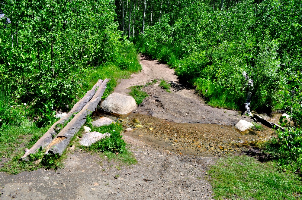
This is the first water crossing. Use the logs to cross this unnamed stream.

At 0.5 miles into the hike you’ll enter the Lone Peak Wilderness
You’ll continue heading up hill through aspens where your best chance for spotting wildlife will be. We’ve seen moose and deer in the groves of aspen. If you do see wildlife along the trail, do not approach them, especially moose. They are rather temperamental and can charge. They can weigh anywhere from 800 lbs to 1500 lbs.

The trail gradually gains elevation and the aspens will thin out as the trail turns to the right from north toward the east. After about another 0.3 miles, you’ll get to the second and last stream crossing. This one is Spring Creek. The water is only about a foot deep depending on the season, but there are rocks that could be slippery. Most people choose to cautiously cross the stream on a series of fallen tree trunks and branches. This is a great spot to take a quick break and take some pictures as there are some short cascades a little ways upstream.
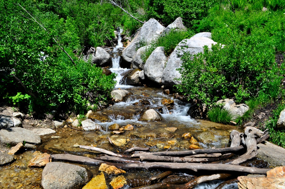
Use the wood branches to say dry and cross Spring Creek. This is the second creek crossing.
After you’ve crossed Spring Creek, be careful and avoid the tall stinging nettle that lines the right side of the trail. If you don’t know what stinging nettle looks like, click here to see a picture and read up about it, so you can avoid this unpleasant plant on your hikes.
After you’ve successfully avoided the stinging nettle, you’ll continue on the trail and take the first long switchback, that will have you heading back north again. This switchbacks is 1.0 mile from the trailhead and nearly the halfway point to Silver Lake. The trail then crosses a subtle ridge which will block out the sound of the creek that you’ve gotten accustomed to hearing, but only for a couple of minutes. You’ll have good views of Silver Lake Flat Reservoir, where you started, as well as good views of Mount Timpanogos.
The shade is now gone for the remainder of the hike up to Silver Lake. A little ways farther up the trail is a small erosion spot or rock slide area that you will have to cross. From there you’ll be able to look down and see where you crossed the creek. At this point you have gained almost half of the 1400+ feet of elevation. You’ll also start to get good views of the small waterfalls along Spring Creek, as well as an idea where the lake is. Spring Creek is the runoff from Silver Lake.
The trail will become a little more rocky, with basketball-sized rocks of quartz monzonite replacing the baseball-sized rocks along the path. The last half mile of the hike is the steepest part, yet the switchbacks do a great job taking the bite out of the last 700 feet of elevation gain. Unfortunately, instead of using the switchbacks, some hikers have blazed other trails up to the lake. This is called “shortcutting” which can confuse hikers and cause erosion. Switchbacks not only make elevation gains more gradual for hikers, but they also cut down on erosion. Please resist the temptation to use the shortcuts and stay on the designated trail.
Once you’ve navigated the final short switchbacks you will have arrived at Silver Lake. During some years, Silver Lake is still frozen into May or early June. Over the years, we’ve been to Silver Lake five times during the month of June, and only once was it partially frozen. Silver Lake is fed by the snow melt of the soaring peaks which surround the glacial bowl. White Baldy, the prominent peak across the lake rises to an elevation of 11,321 feet.

The rugged White Baldy at 11,321 towers over Silver Lake

Silver Lake is a great summer hike
A faint trail is visible around most of the Silver Lake, but most hikers are content with staying near the south side of the lake. Once at the lake, you’ll find that a dam of local rock was constructed to maintain the water level of the lake. Spring Creek is the runoff near the end of the rock/earthen dam. The water in the Lake is very cold and you can see fish jumping in the Lake.
If you find that you have energy to spare, Silver Glance Lake lies directly north of Silver Lake. It’s about one quarter the size of Silver Lake, but makes for a very beautiful setting. To reach Silver Glance Lake, you’ll add another 900 feet of elevation in about a mile. There is a faint trail up to the lake, marked by cairns, but one can use basic route finding skills to get there. Silver Glance Lake can be frozen until late June as it sits at an elevation of 9985 feet.

In this picture you can see Silver Glance Lake in the bottom right, followed by Silver Lake. Silver Lake Flat, where you started your hike, is on the left side of the picture
Silver Lake is a great place to cool off in the summer, fish, or camp. When you’re ready to head back, just return the way you came.
Enjoy the hike!
(We’d love to meet you! Connect with us on our YOUR HIKE GUIDE on Instagram or Facebook.)


1 Comment
Pingback: Access from American Fork Canyon | Alpine Area Hikes