

If you’re looking for a remote location with amazing rock colors and formations and little foot traffic, then White Pocket is the perfect place. Now this place isn’t for the unprepared. You will need to have a 4WD vehicle, preferably with high clearance. You’ll be driving through deep sandy roads for at least an hour and a half off the main House Rock Valley Road. Be sure to check the current conditions of the road at the BLM Office located at 745 East Highway 89. This is a great trip to do in conjunction with the Wave or Buckskin Gulch.
White Pocket Hike Details
Distance – 1+ miles roundtrip
Approximate hiking time – Varies on how much time you want to spend there
Elevation at Trailhead – 5646 feet
Difficulty – Easy
Trail – Sand and sandstone
Amount of water recommended – 2+ liters
Bathrooms – None
Season to hike – Year-around if road is passable due to deep sand.
Special considerations – A 4WD vehicle is necessary, high clearance is recommended.
Permits – None needed at this time
What to bring? – printable hiking checklist
How to get there:
The first thing to do is to stop at the Kanab Visitor Center at 745 East Highway 89, and ask about the road conditions to White Pocket. They also have a detailed map to White Pocket as you’ll be traveling for an hour and a half on dirt and deep sandy roads.
From Kanab, Utah take US-89 east for 39 miles. The road will take a sharp curve to the right (south) and then make another sharp curve to the left (east). House Rock Valley Road is a gravel road that turns off and goes straight instead of taking the tight curve that goes east. There is a sign to help you make the turn off. Use your turn signal early as there is no turn lane.
If coming from Page, Arizona, take US-89 north/west for 33 miles from the Glen Canyon Dam. At about 32.5 miles from the Glen Canyon Dam on US-89 the road will make a tight curve to the north, when you nearly completed the curve the turnoff onto House Rock Valley Road will be on the left side of the road.
Head down House Valley Rock Road for 20.2 miles. The road is rough and prone to washouts. At 20.2 miles, you will turn left at an old corral onto Pine Tree Road/Road 1017 and head east for 6.2 miles, avoiding all side roads. You will then come to a farm house. You will turn left as the road will go in front of the farm house and begin to head north. This is Road 1087. At approximately 3.9 miles from the farm house you will take the left fork and continue on the left fork for 5.6 miles before you arrive at the White Pocket parking area. Along the way you’ll come to a cattle fence crossing the road. Close the fence behind you. It should take about 90 minutes to get to White Pocket after turning off House Rock Valley Road.
If coming from the south on US-89A, turn right onto House Rock Valley Road, and head north. There are two older businesses right off the turnoff. Take House Rock Valley Road for about 9.2 miles until you see an old corral on your left. Turn right here and follow the directions listed in the paragraph above.

White Pocket is very remote. Have all the necessary provisions before you go.
(See the Google Map for this hike at the end of the post)
Hitting the Trail!
You may not understand just how remote this place is until you finally pull up to the trailhead. The parking area is a large, but you’ll never see more than a couple of cars at most. If you’re looking for solitude, this is your place.
While White Pocket has been getting increased media attention recently, it is still far enough off the main highway to limit the number of visitors.
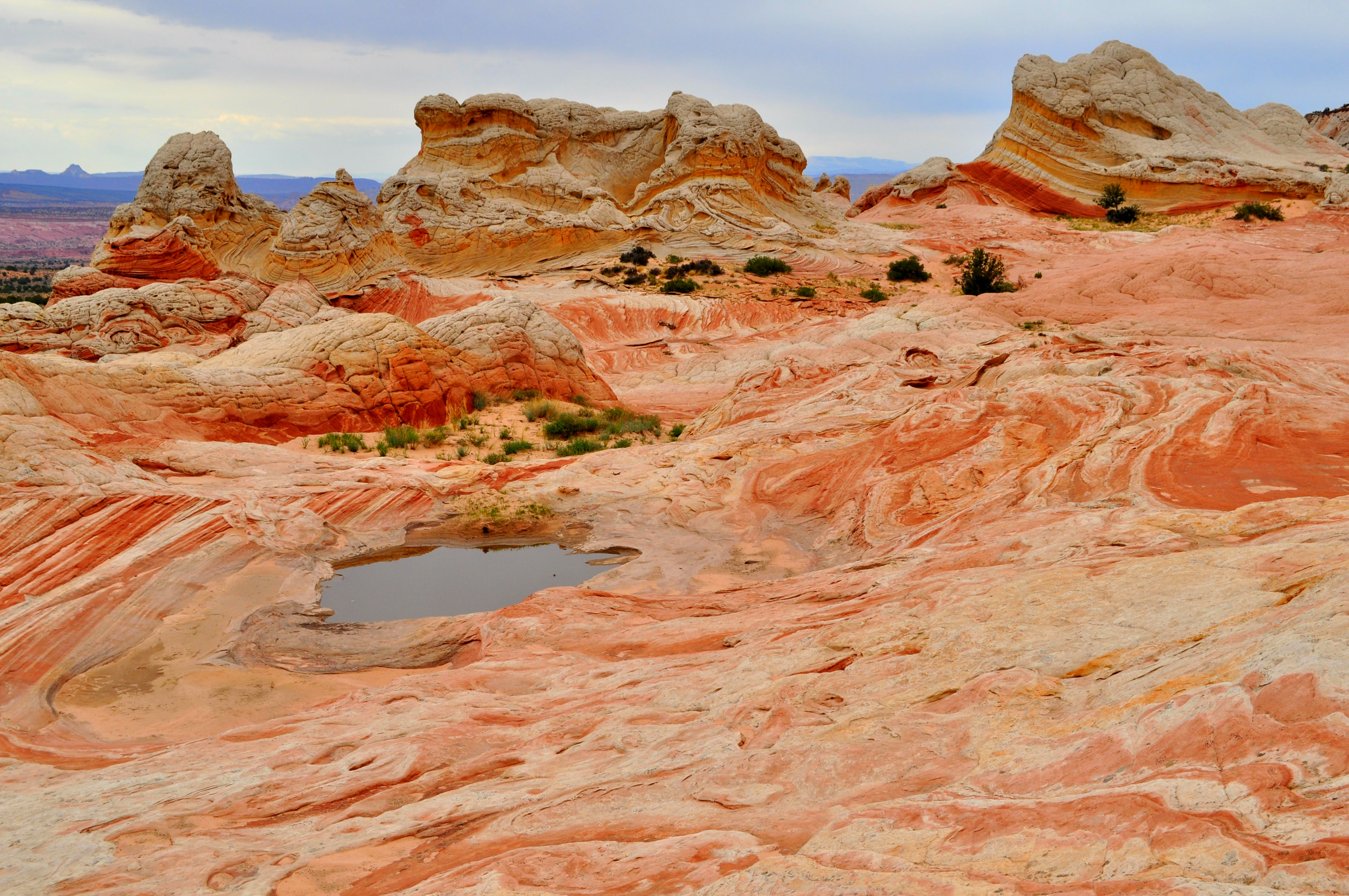
There is a sandy trail that leads for about 100 yards from the parking area. After that, there is no set trail, as you are free to explore along the colorful slickrock. You can easily spend several hours exploring the formations tucked in and around White Pocket. The traverse across the slickrock is easy and fun, and each step is a view to something unique and picturesque.

You could stand in one place, and in each direction there was something amazing to see

There’s a good chance you’ll be the only ones at White Pocket

I’m not sure if it’s possible to take a bad picture here
White Pocket is best photographed in sunny weather conditions, as the blue skies contrast nicely with the colors in the rock. As with any place in the southern Utah/northern Arizona, the temperature reaches into the 100’s in the summer at White Pocket so bring plenty of water, food, and an accurate map.

White Pocket needs to be on your Bucket List!

White Pocket has different and unique colors with every footstep
What to Bring:
Here’s the printable packing list

Shoes: I recommend footwear that can drain sand and grip the slick rock. Here are some good options:

Navigation: You’ll want to take the Pariah Canyon, Kanab and a GPS on this excursion.


This may be my favorite picture from the trip
Have a great time!
(P.S. We’d love to meet you. Connect with us on our YOUR HIKE GUIDE on Instagram or Facebook.)
To see more of our favorite hikes in this area, click here.

19 Comments
I have seen a post from someone that was afraid of the sand on the road (his friend got stuck on another trip and it was very stressful) and instead decided to drive up to the Pawhole trailhead and hike the 7 miles to White Pocket instead. Is that feasible ?
Carlos,
That is a very good question. One of the first things I talk about in my post about White Pocket is to stop by the BLM Office at 745 E. Highway 89 to get the updated road conditions. They can vary greatly. One time I went there and they recommended only high clearance 4WD vehicles, and even they could have trouble that day. Another time I went, and I was told that a front wheel drive vehicle would be fine. It all depends on the weather.
As far as Paw Hole TH, while you don’t travel as far and as long on the sandy roads, it is also recommended to have 4WD to reach it. (Talk with the people at the (Paria Contact Station or the BLM Office in Kanab.) I suppose that it is possible to hike to White Pocket from Paw Hole TH, but I’ve never tried it. If you walk along BLM 1079, it’s going to be about 9 miles one way. I’m assuming that your 7 miles would be cross-country, going entirely off of maps and GPS? That could be tricky, and I wouldn’t recommend it. There are guide groups in Kanab that can take you out there if the roads are passable. As you know, safety first. That area out there is very remote. It can be bad enough if you get stuck on a road, but if you get in trouble while hiking cross-country to White Pocket, it might be the end of you. Hopefully that helped any questions you might have. If not, you can email me at yourhikeguide@gmail.com. Thank you for stopping by!
Thanks for your message Carlos! Yes, the road conditions can vary dramatically depending on the weather. I sent you a message to your email address. I hope that helps!
Hi, Adam. Your website is such an awesome resource! So glad I came across it.
We’ll be in the area towards the end of March. Our original plan was to spend an entire day checking out White Pocket, camping in our truck tent, and leaving after watching the sunrise the following morning. While it would be cool to see the area at different times of day, we’re on a bit of a tight schedule if we are to see all the things we’d like to on our way down to Surprise, AZ the following day (going to a Royals spring training game that evening–GO BLUE!). I was under the impression White Pocket required a full day to see. What are your thoughts? If we started out early enough in the morning, would we be able to be on the road and moving onward by early afternoon? Or, should we go ahead and allow a full day for exploring?
Any and all suggestions would be greatly appreciated!
Haylea, I’m so glad that you are finding my website useful. I’ll send you an email with my advice and suggestions.
We are planning a day trip to White Pocket next week. It looks like an amazing place. We have a customized Jeep Wrangler Rubicon and have done a lot of off-road travelling so aren’t worried about driving the sand road. I’ve seen the videos on You-tube of the drive and we’ve done much worse but was wondering if you have GPS coordinates for the turnoffs to keep us on track. Also, we will be staying in Page, AZ and travelling from that direction to House Rock Valley Road. Does the Visitor Centre there have detailed maps of the area? Any advice would be much appreciated.
Donna,
You’ll be fine with your vehicle. You should be able to pick up a map of the roads to White Pocket. I’ll see if I can send you a PDF of the map. The Kanab BLM office and well as at the Paria Contact Station should have the same map. Here is the phone number to the Paria Contact Station (435) 644-1200. Let me know if you have any more questions.
Hi Adam,
I am planning a trip out there at the end of the month. Are you able to send me the PDF you sent to Donna? If so, I can send you an email. Thanks in advance for your help.
Matt
Hi Adam,
You have very helpful website. Going to White Pocket this Saturday. Can I have the PDF with GPS coordinates as well? Thank you.
Sasha
Sasha,
I’m glad that you have found the website helpful! I will try and send you a PDF tonight. Either way, I would recommend going to the Kanab Field Office, where they do the lottery drawings for The Wave and ask for a map at the front desk as well as the current road conditions to White Pocket. They will have up to date information on the road conditions.
Hi Adam, Awesome resource! You made my night finding your site. Can you tell me about any of your favorite slot canyon hikes near Lone Rock or Wahweap. Heading there the Friday of Memorial weekend, spending the day hiking instead of boating and looking for something other than Antelope. Any ideas most welcome!
Mary,
I’m glad that you have find the site useful! It sounds like you have a great Memorial Day planned! I’ll be sending you an email with my ideas for you. Have a great weekend!
Thank you! Look forward to your email!
After Lake Powell, heading to Zion. We’ve hiked Angels once. What do you think of Observation or Hidden Canyon. Any ideas most welcome!
What do you think will Lower Narrows be like, late May?
Adam,
It’s always great to communicate with “Eagle Scouts!” I got mine in November, 1968 with Pres. Johnson’s signature on it. so you know that I have some miles on me! My wife and I are going to be in the Cedar Mesa area and are going to visit Capitol Reef and Bryce on the way back to Phoenix. I would like to try to hit White Pockets if we can since we’ll be in the area. I don’t have a lot of experience on dirt roads, but we are going to rent a 4 wheel drive Jeep of some sort. I’ve read your suggestions about checking out the road conditions and I will copy all your instructions. How would you rate the attempt at finding the place and managing the hour and a half drive for a first timer like me. Any comment or other tips outside of common sense ones like takes lots of water much appreciated,
Sincerely with a “left-handed” Boy scout skake,
Ed Burns, from the Chicago area
Hi Adam.
This is great, thank you. I’m headed there this weekend. Would you be able to send me the pdf map? I’ll be arriving well after the visitor center closes and hoping to be in white pocket the following morning before they open. I talked to the ranger station on road conditions and they sound ok, just deep sand. Also, I have a full day dedicated to this area, and could hang around longer if necessary. Is there a particular time that is great to be there, i.e. sunrise, sunset, etc. Any advice you could offer would be great.
Thanks so much.
Jon
I sent you an email. I hope that you have a great trip!
Would you kindly email me the PDF? I hope to approach from 89A coming from the south, so Paria Contact Station is a bit out of the way. Thank you!
Hi – This site is great. We have permits to see the Wave at the end of January. Want to see the white pockets – but we have a subaru crosstrek? It’s AWD and moderate clearance. Would this vehicle be appropriate? We’ve driven to the Wave trailhead before and had no issues. We have two Vizsla’s with us so we are trying to find some fun remote areas to explore where they can romp about without disturbing tourists and driving us nuts 🙂
Thanks!
Amy
Thank you for visiting YourHikeGuide.com and for your nice words. I have sent you a message to your email that should help you out a lot! Let me know if you have any other questions!