

Buckskin Gulch! Widely known as the longest slot canyon in the world, this 20.6 mile hike is one for the books. Backpacker Magazine even named it the most dangerous hike in the United States due to the extreme flash flood danger. Makes you want to hike it tomorrow, right?!
Buckskin Gulch Hike Details
Distance – 20.6 miles roundtrip, and a car is needed at each trailhead
Approximate hiking time – Anywhere from 10 hours to 2 days, depending how fast you go, and if you’re spending the night
Elevation at Wire Pass Trailhead – 4860 feet
Elevation at the confluence of Buckskin Gulch and the Paria River – 4100 feet
Elevation Loss of 760 feet to the confluence with the Paria River, and a gain of 180 feet from the confluence to White House Trailhead
Difficulty – Moderate
Trail – sand, large and small rocks, and numerous stagnant pools may need to be waded.
Amount of water recommended – 3 liters
Bathrooms – Yes, located at Wire Pass Trailhead and White House Trailhead
Season to hike – March to July, mid-September to November, but it all depends on the weather
Prone to flash floods? – Yes, Buckskin Gulch is deadly. If there is a chance of rain in the forecast, don’t do it. Closely monitor the weather report.
Permits – If hiking straight through, just a $6 per person day pass is needed, and can be picked up at either trailhead. If staying overnight, you’ll need to secure a limited number of overnight passes.
What to bring: (printable packing list)
How to get there:
From Kanab, UT head east on Hwy 89 for 44 miles until you spot the sign for the Paria Ranger Station. Turn right into the ranger station. The road to White House Trailhead is on the left of the road to the ranger station. There is a sign to lead you. Follow the dirt/gravel road for 2.1 miles. It will end at the White House Campground. Leave one car here. Take the other car to the Wire Pass Trailhead. To get to Wire Pass, from the ranger station, turn left on Hwy 89, and head west for 4.9 miles. After the road takes a sharp curve to the right, you will make a quick left onto House Rock Valley Road. It is a well-maintained dirt road. Both roads to each trailhead are prone to washouts after hard rains. Once you turn onto House Valley Rock Road, take it south for about 8.5 miles. You will see a sign for the Buckskin Gulch trailhead after about 4.5 miles. Do not stop here. Continue for another 4 miles to the Wire Pass Trailhead. You’ll see a large parking area on the right side of the road. Park here. (See the Google Map I created for this hike at the end of this post.)
Hitting the Trail!
This is a hike only for those that are well-prepared. A flash flood while in Buckskin Gulch is deadly. Flash floods up to 100 feet high rip through Buckskin Gulch, as evidenced by full-sized logs wedged dozens of feet over your head. With the walls hundreds of feet above, there is little or no escape from a flash flood. Make sure that there is no rain in the forecast. Storms as far away as Bryce Canyon can bring a wall of water into Buckskin Gulch. Be sure to carry plenty of water for your entire hike, as water in the gulch is not clean nor reliable until late in the hike. All of this aside, Buckskin Gulch is an amazing hike, and will test your endurance while rewarding you with an experience that you will always remember!
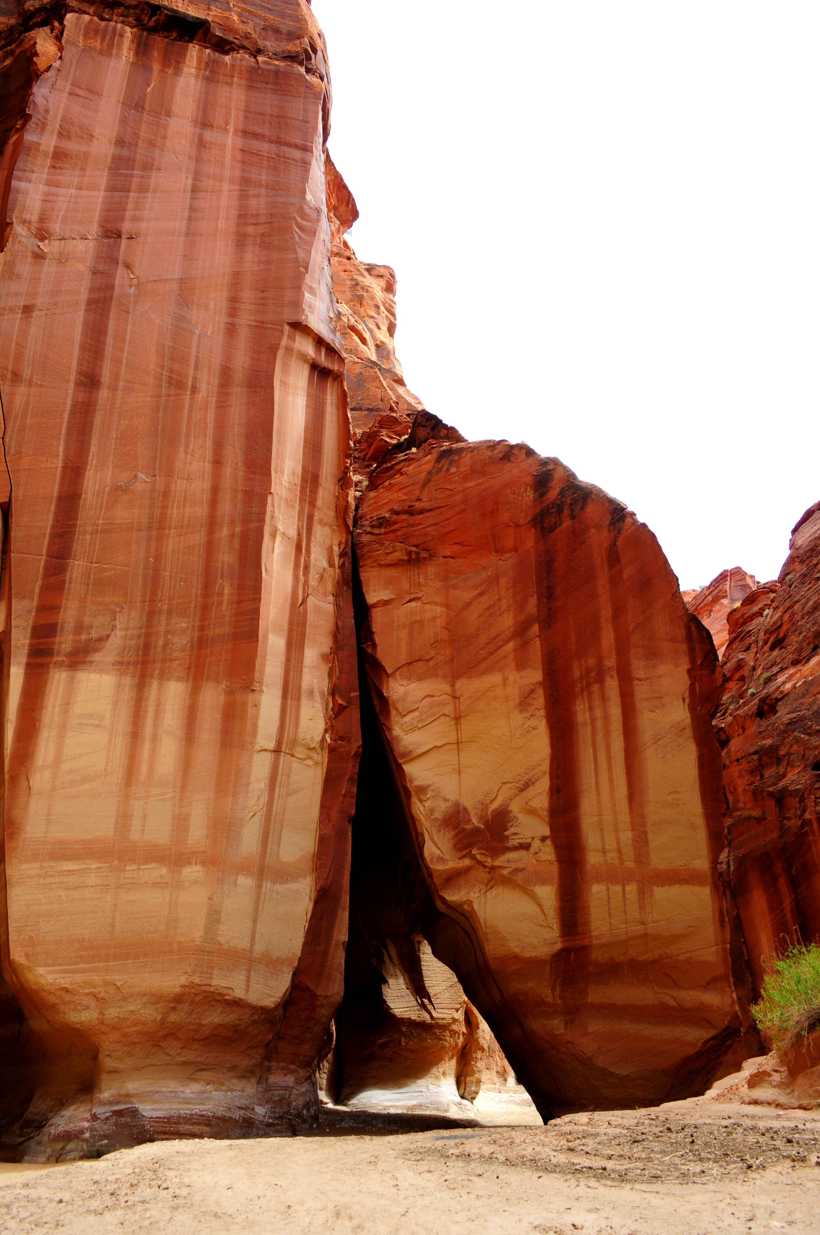
After dropping off a car at the White House Trailhead, you’ll drive your other car to Wire Pass Trailhead to start the hike. If you plan on hiking through Buckskin Gulch in one day, be sure to get an early start! Make sure that the weather report is free of rain. Even a 10% chance is a great risk. The drainage into Buckskin Gulch takes in a huge drainage area, so even though there are clear skies above, it could be raining 50 miles away, sending a flood of water right down Buckskin Gulch. The flash flood season in canyon country is from July to mid September. About 8 flash floods scour Buckskin Gulch each year, and each trip down the Gulch is different because of these flash floods. Log jams, chockstones, and boulders brought from the flash floods can litter the canyon floor. This hike through Buckskin Gulch and up the Paria River is 20.6 miles in length, and can require wading through several stagnant pools or none at all, it just depends on your luck. As you leave the Wire Pass parking area, head east across the road and follow the trail that parallels the dry wash for about a quarter of a mile before passing through a cattle maze gate. Shortly thereafter, you will drop into the shallow wash, which is Wire Pass. After about ten minutes, you will continue down the wash, while a small trail breaks off to the right. This trail will lead you to The Wave. After hiking for about .75 miles, Wire Pass begins to constrict and the canyon walls begin to rise quickly. This first narrows section in Wire Pass has a small obstacle that requires you to downclimb about 8 feet, which is easily cleared. After going 1.7 miles in Wire Pass it will open up and you’ll arrive at the confluence of Wire Pass and Buckskin Gulch, but before you exit Wire Pass, look closely on the canyon wall on the right-hand side. You’ll see a panel of petroglyphs of bighorn sheep.

This is a narrow part of Wire Pass just before the confluence with Buckskin Gulch

800 year old rock art, found near the confluence of Wire Pass and Buckskin Gulch
Leaving the confluence behind, Buckskin Gulch quickly narrows and the walls begin to rise, making you feel very small. You’ll find that in the first couple of miles in Buckskin Gulch you won’t be able to put down your camera. The lighting in Buckskin Gulch in remarkable in the morning hours, and the canyon walls glow rich golds, oranges, and reds. Enjoy this part of Buckskin, but don’t spend too much time, you still have another 11+ miles of this magnificent gulch. Each flash flood changes the canyon floor. Sometimes there are long stretches of rocks ranging from baseball-sized to basketball-sized and can make the going slow. Take your time as to not sprain an ankle. You will find some stretches of deep sand as well during your trek in Buckskin Gulch. Each time I’ve hiked through Buckskin Gulch, I’ve come across rattlesnakes. Most of the time, you won’t even know that you’ve passed by them. They are small and tend to hide. If you see one, allow it space to slither away which may be difficult in narrow sections, but give the rattlesnake time to get away.
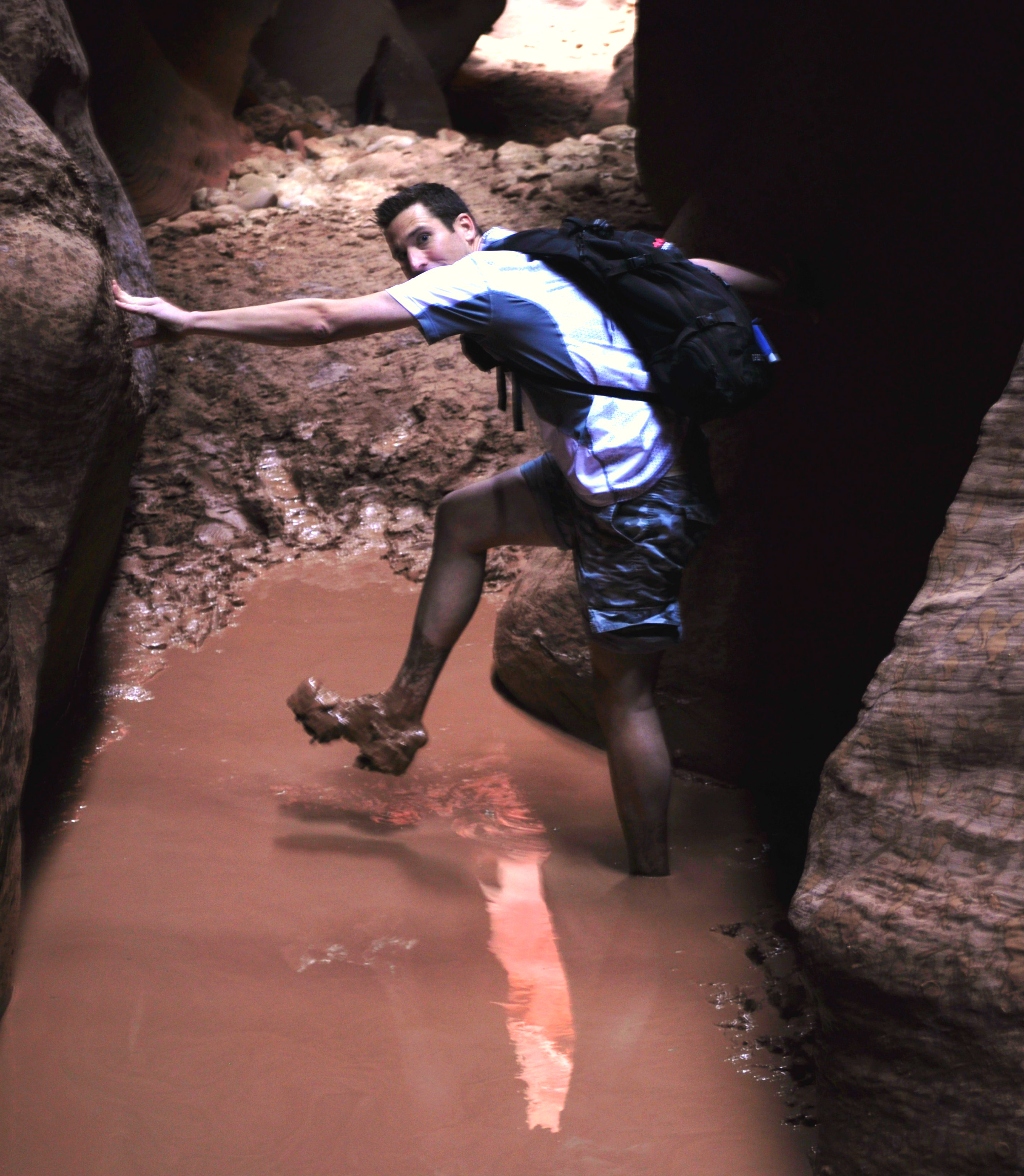
Depending on the amount of rain, the Cesspool can range from knee to neck deep.
The first time I hiked all Buckskin Gulch and didn’t have to wade one pool, however, when I hiked Buckskin Gulch again in May of 2013, it hadn’t rained in about a month, yet we still had to wade through three knee-deep pools before we even reached the infamous “Cesspool” which was about 35 feet long and just under knee-deep. It smells… putrid. Yes, putrid is a great way to describe it. This “Cesspool” on very rare occasions is bone dry. Other occasions, hikers wade in neck-deep stagnant water for 150 feet. Be prepared for wading. It is typically between knee and waist deep, and is similar to the consistency of chocolate syrup. I would recommend wearing or bringing along water shoes, because walking with wet socks and sneakers for 20.6 miles can be miserable. The cesspool is about 7.5 miles from the Wire Pass Trailhead. About one half mile past the cesspool, the canyon walls lower to about 100 feet, and on the left side of the canyon you may spot the Middle Route exit, which is a Class 3 scramble to the canyon rim. Some backpackers exit the canyon here to set up camp and spend the night, but if you’re planning on completing the hike in one day, just keep on going.  Nearly four miles after the Middle Route exit, you’ll arrive at the only big obstacle in Buckskin Gulch, a 15-18 foot dryfall that you can descend with the aid of a rope and moki steps chipped into the rock, or you can climb down it with two logs wedged together. It’s not too difficult to navigate, just take your time. I brought my own rope just in case, but there was a rope waiting there for us to use. It’s about another 1.5 miles to the confluence of Buckskin Gulch and the Paria River. Water will seep from the canyon walls, and will collect on the canyon floor in a shallow, clear stream and run down to the confluence.

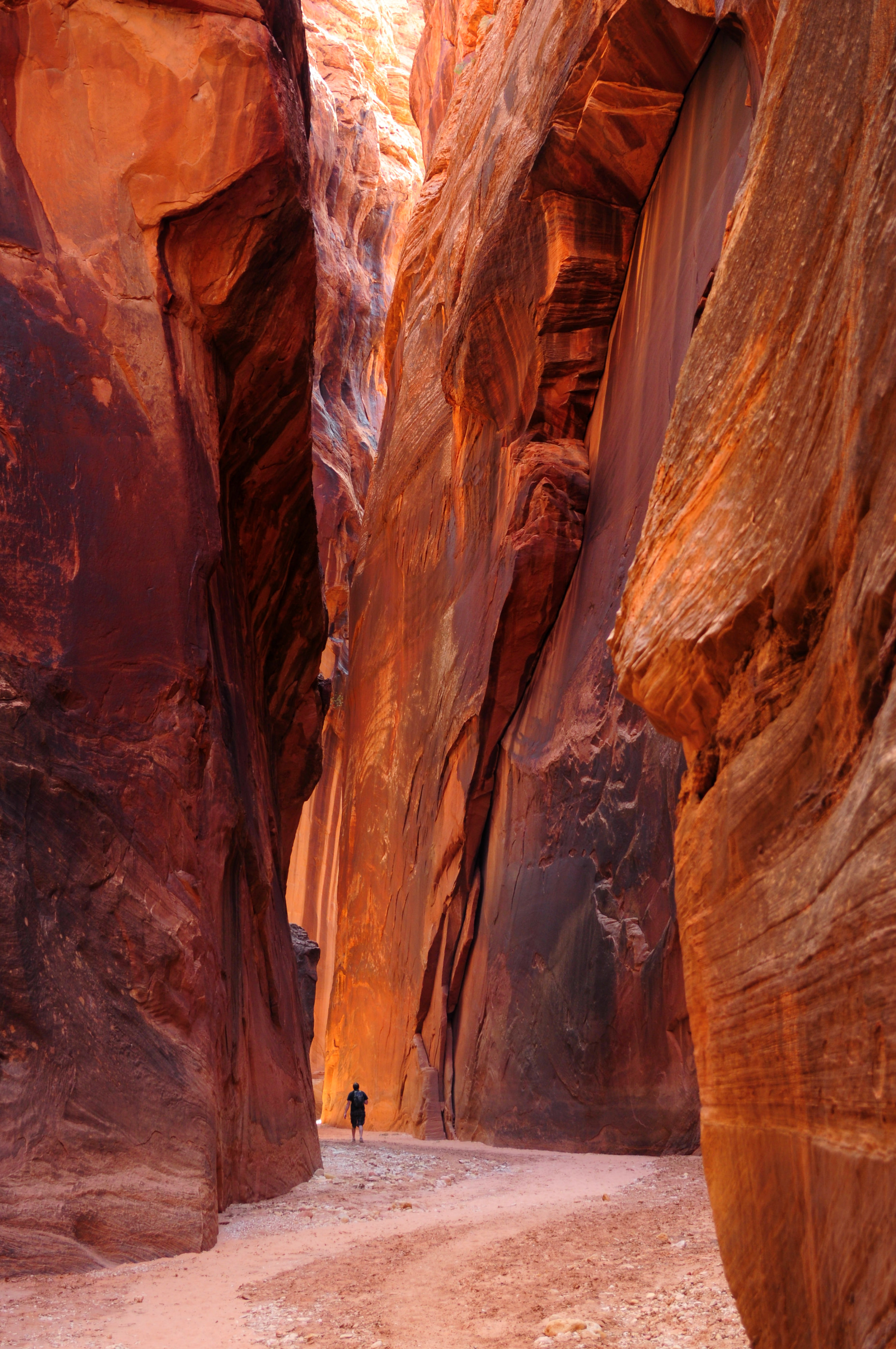
Near the confluence of the Paria River, the canyon walls soar over 400 feet high
At the confluence, the canyon walls are over 400 feet high. Turn left and head up the Paria River. Sometimes there is water flowing out of the Paria, other times there is not. Once in the Paria River, you’ll follow it for 7.1 miles to the White Horse Trailhead. You’ll end up crossing the Paria River, which is rarely more than calf-deep countless times, so once again, I would recommend wearing water shoes. One of the highlights of the Paria River canyon part of the hike is Slide Rock Arch. While it’s not really an arch, it is impressive nonetheless and is located about 1.5 miles up the Paria from the confluence.
Slide Rock Arch, though not really an arch, it is still very impressive.

Near the confluence with the Paria River, just past the spring
This part of the hike, especially as the Paria canyon opens up can be very hot in the afternoon, and there is little shade from the sun. The Paria River canyon would normally be a beautiful and scenic canyon, however after spending the last six hours within the narrow walls of Buckskin Gulch, the Paria won’t seem too impressive. At 17.8 miles, you’ll pass under some power lines a little over 2.5 miles from your destination of the White House Trailhead. As long as you maintain a comfortable walking pace during the hike through Buckskin, you should be able to finish the hike in about 12-13 hours. We were able to finish in 9 hours and 45 minutes, which included just a couple of ten minute breaks. Since you are losing over 700 feet in elevation from Wire Pass to the confluence of the Paria River, the going will be fairly easy. Below are some of my favorite pictures in Buckskin Gulch. The colors are amazing, and you really get a perspective of how deep Buckskin Gulch really is!
Deep in Buckskin Gulch

You feel very small when hiking through Buckskin Gulch
What to Bring: (printable packing list)
For this hike, I recommend lightweight, close-toed water shoes with good traction. These are some of our favorites:

Enjoy the hike!
P.S. We’d love to meet you. Connect with YOUR HIKE GUIDE on Instagram or Facebook.
For more hikes in Southern Utah, click here.


15 Comments
Love your posts!
Thanks so much Robin!
Nice job…best post on Buckskin I have seen.
Thank you Tim!
Hey ! thank you for the amazing trail description. I would love to be able to see the “long flat wall” narrow part of the canyon but I won’t be able to go all the way from Wire pass to White house… How long did he take to walk until this part (typically until the area of the last two pictures ! 🙂 ) from Wire Pass or White house trailhead ??
Looking forward to your answer !
Pierre,
I hope my email was able to answer all of your questions. Let me know if there is anything else that I can help with.
Pingback: National Park Adventures for Scouts: Grand Staircase/Escalante National Monument | Voice of Scouting
Hi,
I’ll be doing a Southern Utah roadtrip at the beginning of October. I was wondering if you knew any good day hikes around Paria Canyon- Vermilion Cliffs? Also planning to go to Lake Powell, but we don’t have a boat. If you had any ideas on that. Your site is great and very informative. Thanks!
Tara,
I sent my recommendations to your email address. Happy hiking!
Hello, Adam.
I’m considering going to southern Utah for Christmas and would really love to see the place where you took the first picture in this post. I’m not looking to hike the whole pass – maybe just 3-4 hours round trip.
Is it ok to do this time of year?
Maureen,
Thanks for visiting YourHikeGuide.com. Buckskin Gulch is an amazing place! The first picture in the post (not the profile picture) is located in Wire Pass slot which you go through to reach Buckskin Gulch. This is right before the confluence of Wire Pass and Buckskin Gulch. Is that the photo you’re referring to?
If so, you’ll easily see this within your first 30-45 minutes of hiking. It may be a little chilly down there, but you should be able to hike 3 or 4 hours roundtrip in Buckskin without a problem. Just to be on the safe side, I would recommend stopping by the Kanab Visitor Center at 745 East US-89, Kanab or call (435) 644-1300 ext. 1301 to get the current conditions inside Buckskin Gulch. The only problems I could see would be the condition of the road down to Wire Pass if there has been recent rain/snow, and the amount of standing water in the Gulch.
Good luck! I hope that helps. Let me know if you have any other questions.
Thank you, Adam.
Hi Adam, We plan on going out there late February arriving mid morning on Thursday. We want to start from wire pass to white house. Do you think 3 nights would be enough? We dont want to be rushing. Or will 2 nights be enough ?
Thank you for your message Jesse. I have sent you an email that should answer any questions you have. Thank you for visiting YourHikeGuide.com
Jesse,
I sent you an email that should answer all of your questions. Let me know if you have any more!