
")
Bald Mountain, located in the Uinta Mountain range, is the easiest 11,000+ foot summit that a hiker can find in Utah. At 11,945 feet, it is taller than any other peaks in the Wasatch Mountain range, which can be seen some 50 miles to the west. Bald Mountain offers excellent views of the dozens of lakes that are found in the Uintas, and can be combined with Reids Peak to the north or Murdock Mountain to the south for a solid day hike.
Bald Mountain Hike Details
Distance – 3 miles roundtrip
Approximate hiking time – 1.5 to 2.5 hours
Elevation at Trailhead – 10,764 feet Elevation at Summit – 11,945 feet
Elevation gain – 1181 feet
Difficulty – Easy-Moderate
Trail – Rock
Amount of water recommended – 2 liters
Bathrooms – Located at the trailhead
Season to hike – Mid June to late September, depending on the snowfall
Permits – Recreation passes can be picked up at the self-service fee stations along the Mirror Lake Highway.
Pets allowed – Yes
How to get there:
From Salt Lake City, take Interstate 80 east to the Silver Creek Junction/US-40 (Exit 148) Turn right and go south on US 40 for 3.4 miles to UT-248 (Exit 4) At the end of the off-ramp, turn left and continue on UT-248 for 11.4 miles to South Main Street (UT-32) in Kamas. turn left on South Main Street (UT-32) in Kamas and go north for two blocks, then turn right onto Center Street (UT 150). This road, once outside of Kamas becomes the Mirror Lake Highway (UT 150). You’ll continue on this road for about 29 miles to the Bald Mountain trailhead. There will be a sign for the trailhead before the turnoff. Find a spot in the large parking lot, which is almost always full during the summer weekends. If you’re coming from the south (Las Vegas), take Interstate 80 to Orem 800 North (Exit 272) Take the off-ramp and head east on 800 North for 3.5 miles to the mouth of Provo Canyon. Take the ramp to the left and merge onto US-189. Stay on US-189 for 21.5 miles. You’ll come to a stoplight in Heber, and turn left and go through old downtown Heber on US-40. Follow US-40 (also Main Street) for 4.7 miles, where you will turn right onto UT-32. Take UT-32 for 10.4 miles, at which point you’ll be in the village of Francis. Turn left at the one main stoplight/stop sign. This is still UT-32. Take this road for 2.3 miles into Kamas. Turn right onto Center Street (UT-150 ) This road, once outside of Kamas becomes the Mirror Lake Highway (UT 150). You’ll continue on this road for about 29 miles to the Bald Mountain trailhead. There will be a sign for the trailhead before the turnoff. Find a spot in the large parking lot, which is almost always full during the summer weekends. (See the Google Map for this hike at the end of this post)
Hitting the Trail!
Perhaps the biggest obstacle to overcome on this hike will be the altitude. For most hikers, the elevation at the trailhead will be about 6000 feet higher than they are accustomed. Gaining all that altitude in your vehicle will not give your body time to acclimate to the thin air, etc. I would highly recommend drinking plenty of water the day before the hike to aid in lessening the chance of Acute Mountain Sickness. I also suggest that you take a slower pace on this hike. It’s only three miles roundtrip, so you’re really in no hurry. Most of us in Utah are accustomed to having 15% less oxygen than those at sea level. However, at almost 11,000 feet, you have 35% less oxygen than those at sea level. Give your body time to adjust to the lack of oxygen. At the end of the parking lot, past the bathrooms, the trail starts. As mentioned, Bald Mountain is an extremely popular destination each weekend from the end of July to mid September. Expect to see dozens of hikers of all ages and skill levels. If you are seeking more solitude, I would recommend going during a week day morning. It also gives you a better chance to spot mountain goats, which frequent Bald Mountain. The beginning of the hiking begins through a small grove of spruce and then the trail begins to wind to the west and completes four switchbacks before heading west for the next 0.4 of a mile. At this point, you’ll enter the small group of stunted vegetation before you have cleared the treeline. The trail turns northeast and you’ll find yourself on gradually gaining elevation along a field with small to medium-sized slabs and lichens. The view really begin to open up at this point to the west.
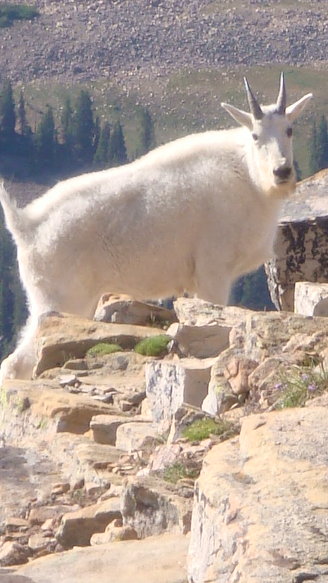
Roofus and I nearly ran into each other near the false summit of Bald Mountain
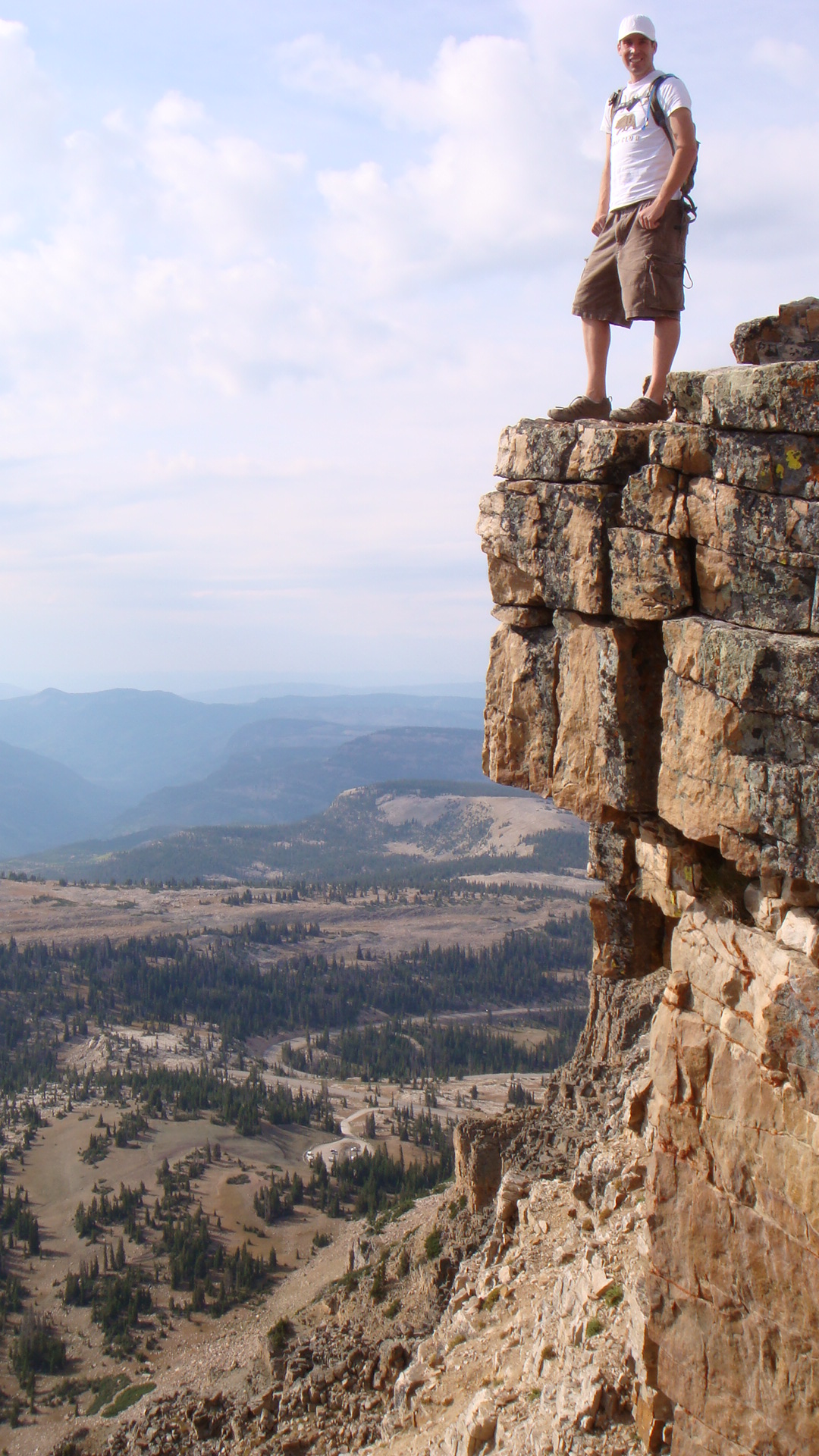
After a about one mile from the trailhead, you’ll head due north and find yourself on the east side of Bald Mountain, making your way up to what looks to be the summit, but it really a false summit. It’s at this point where I usually first see mountain goats. On my first trip up to Bald Mountain, I was in front and had just made it to the false summit at the exact same moment a mountain goat did. We were close enough to give each other a high-five. I have hiked Bald Mountain many times, and I’ve seen mountain goats on each trip. They are very chill and don’t seem to be bothered by our presence on their mountain. And by looking at those horns, I wouldn’t be too worried either if I were them. While they always maintained their distance they were also curious and would watch us intently. The last part of the hike from the false summit to the real summit climbs up giant rock slabs. It is not technical. Shortly after climbing the last section, you’ll find that the top of Bald Mountain is about the size of a football field or two. The views in all directions are very rewarding. You can spot dozens of lakes from the top. The lake directly below and east of Bald Mountain is Moosehorn Lake, with Mirror Lake just a little farther north and east of Moosehorn. Take plenty of pictures while on top and explore the top. There are some great places for awesome shots. After you’ve have your fill of boulder hopping on the summit, just come back the way you came, or if you’re ambitious, you can proceed to Reids Peak, which is the pyramid-shaped peak to the north. Hike down to the saddle between Bald Mountain and Reids Peak, and pick your way up Reids Peak, as there is no trail to the top. It is more challenging and will require some very basic climbing skills. By the time you return to your car after hiking Bald Mountain, you will have just reached the top of a nearly 12,000 foot peak after just completing three miles of hiking. For upcoming hiking and survival posts, follow the Your Hike Guide Facebook page!

At the top of Bald Mountain, with Moosehorn Lake in the bottom left
What to Bring
(Click on an item for more information)

Beautiful views on Bald Mountain

Being young and dumb
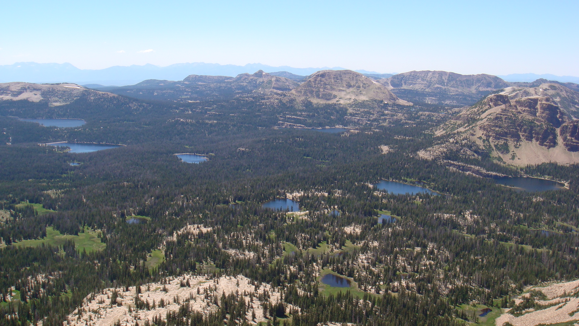
One can see dozens of lakes from the summit of Bald Mountain
We’d love to meet you! Connect with us on our YOUR HIKE GUIDE on Instagram or Facebook.
For more great hiking trails, click here.
")


1 Comment
I’m looking forward to this summer when I can take my famiy on this hike. Thanks for sharing all of these great hikes and great info!